British startup Satellite Vu has raised £12.7 million ($15.8 million) to develop what it calls “the world’s thermometer”: a satellite constellation capable of monitoring thermal emissions around the world.
The Series A-2 round was led by Molten Ventures, with participation from Seraphim Space, A/O Proptech, Lockheed Martin, Ridgeline Ventures, Earth Sciences Foundation, and Stellar Ventures. All of these investors have previously contributed to Satellite Vu. The company has now raised £30.5 million ($37.7 million) to date, including a £1 million ($1.2 million) grant from the UK Space Agency’s National Space Innovation Program.
The London-based startup is developing technology to gather high-definition thermal data from space. The satellites will be able to measure heat emitted from individual buildings, data that the company says can be used to help businesses and governments enact more energy-efficient solutions.
Being able to locate and measure thermal energy output will be essential to achieving net-zero carbon emissions, the company says.
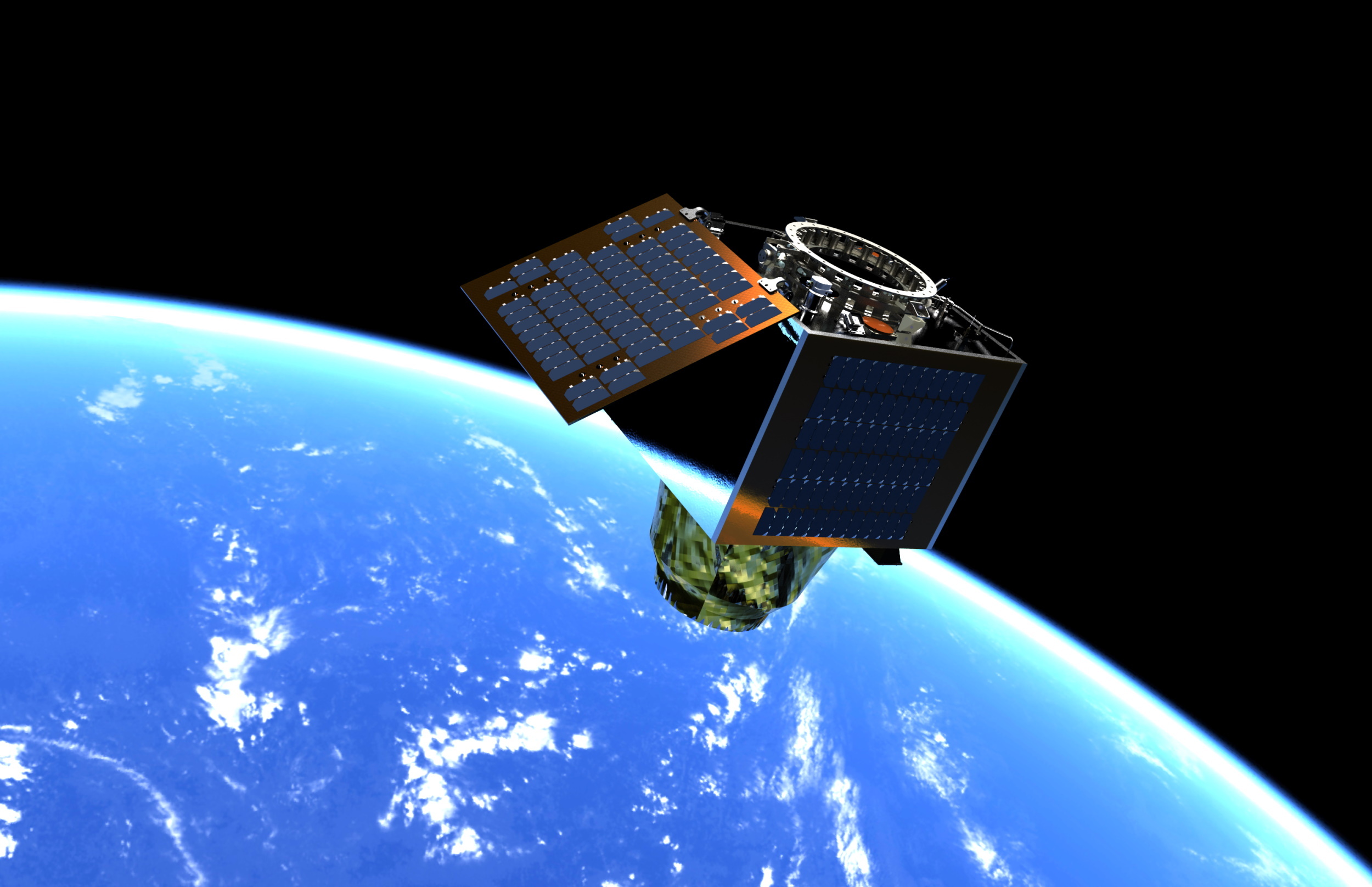
Satellite Vu will be sending its first spacecraft to orbit, a bird built in partnership with Surrey Satellite Technology Ltd, in June on a SpaceX Falcon 9 ride-share mission. The satellite will be able to collect imagery and video at a resolution of 3.5 meters per pixel.
The seven-year-old company has customer commitments valued at over £128m ($160m) via its early access option program, which gives customers preferred access to imagery and the option to secure satellite capacity. Companies that have joined the program include Japan Space Imaging Corporation and analytics company Kayrros. Those funds should start transitioning to revenue from the fourth quarter of this year.
“Their $160m in early commitments is a stellar model of pre-launch sales for deep-tech companies, which other climate-tech firms could emulate,” George Chalmers, Molten Ventures’ head of climate tech, said in a statement.
The new funding was an ‘up round,’ according to Satellite Vu, or a round in which the company’s valuation increased. The company will return to fundraising its Series B after its first launch.
British startup Satellite Vu has raised £12.7 million ($15.8 million) to develop what it calls “the world’s thermometer”: a satellite constellation capable of monitoring thermal emissions around the world.
The Series A-2 round was led by Molten Ventures, with participation from Seraphim Space, A/O Proptech, Lockheed Martin, Ridgeline Ventures, Earth Sciences Foundation, and Stellar Ventures. All of these investors have previously contributed to Satellite Vu. The company has now raised £30.5 million ($37.7 million) to date, including a £1 million ($1.2 million) grant from the UK Space Agency’s National Space Innovation Program.
The London-based startup is developing technology to gather high-definition thermal data from space. The satellites will be able to measure heat emitted from individual buildings, data that the company says can be used to help businesses and governments enact more energy-efficient solutions.
Being able to locate and measure thermal energy output will be essential to achieving net-zero carbon emissions, the company says.
Satellite Vu will be sending its first spacecraft to orbit, a bird built in partnership with Surrey Satellite Technology Ltd, in June on a SpaceX Falcon 9 ride-share mission. The satellite will be able to collect imagery and video at a resolution of 3.5 meters per pixel.
The seven-year-old company has customer commitments valued at over £128m ($160m) via its early access option program, which gives customers preferred access to imagery and the option to secure satellite capacity. Companies that have joined the program include Japan Space Imaging Corporation and analytics company Kayrros. Those funds should start transitioning to revenue from the fourth quarter of this year.
“Their $160m in early commitments is a stellar model of pre-launch sales for deep-tech companies, which other climate-tech firms could emulate,” George Chalmers, Molten Ventures’ head of climate tech, said in a statement.
The new funding was an ‘up round,’ according to Satellite Vu, or a round in which the company’s valuation increased. The company will return to fundraising its Series B after its first launch.
Data is becoming as precious as water in precision agriculture, and Hydrosat aims to help provide both with a new set of Earth observation satellites. The company has raised a $20M A round, including $5 million in non-dilutive funding, which should put the first two thermal infrared satellites into orbit.
The company’s mission is to provide customers from agribusinesses to the government real-time thermal infrared data, which can be used for solutions from drought prediction to ecosystem monitoring to disease vector mapping.
“The ability to track water stress and climate impacts in real time is a critical pain point for Hydrosat’s agribusiness, financial, and government customers,” Hydrosat CEO Pieter Fossel tells TechCrunch. “This need is only being felt more acutely with the increasing pace of extreme weather events brought on by climate change and increasing instability in global food supply chains from geopolitics and the war in Ukraine.”
Currently, Hydrosat develops crop yield forecasts and irrigation management solutions based on open Earth observation data sets. But those datasets are relatively infrequently updated and usually somewhat low resolution. So Hydrosat’s next step is developing its own 16-satellite constellation that will provide constant high-resolution thermal images from space to improve the solutions for customers.
Led by Statkraft Ventures, with additional participants including Blue Bear Capital and Hartree Partners, this funding will “accelerate the commercial go-to-market of Hydrosat’s two core analytics solutions,” says Fossel, nodding to the crop yield forecasts and irrigation management tools.
But it will also go towards the launches of VanZyl-1 and VanZyl-2, the company’s first fully operational commercial satellite missions. Both missions are due to launch next year, with VanZyl-1 securing a flight with Loft Orbital. The funding builds the company’s $15 million seed from 2021.
“Hydrosat flew a prototype thermal infrared mission in January 2021 on a stratospheric balloon at 20-kilometer altitude with support from the U.S. Air Force Space Test Program. That prototype mission flew and imaged successfully at altitude,” says Fossel. “The stratospheric mission served as a major risk reduction milestone for Hydrosat’s first two on-orbit missions and paved the way for subsequent funding and development.”
Once operational in orbit, the satellites will provide “analytics-ready, science-quality data of the entire Earth,” according to Fossel. And that data will provide even richer insights for Hydrosat’s growing client base.
Plenty of companies want to operate in space, but few have or need the expertise to do so. They want an eye in the sky but not a satellite company. Muon Space is one of several startups looking to put others into space but with a special expertise in Earth observation and building the full stack from satellite bus to data on the ground. It has already raised $25 million to do so and locked down a few early big customers.
“People are reinventing large portions of the stack required to collect data from space,” Muon’s CEO and co-founder Jonny Dyer explained. “When we look across the spectrum of different new phenomenologies and missions, many of these companies are developing their own spacecraft, and obviously their own ground segments and data, so they can address a particular vertical market. We think that doesn’t make sense.”
To invent an example, consider a solar farm builder. They want to use satellite imagery to monitor their work and provide a data point on the resilience of their installations over time, looking for things like hot spots, broken panels and so on. They basically have two options. One is to use imagery from existing private satellites like Planet’s, which may or may not collect the type of data they want, at the frequency they want. The other is to build their own satellite and pay to put it in orbit — probably a nine-figure endeavor.
Muon is looking to provide a third option: a specialty space data partner that helps a company build an Earth observation platform from soup to nuts. That means designing the sensors, the bus, the navigation and telemetry systems, and the downlink and ground infrastructure needed to support this data-heavy industry.
Image Credits: Muon Space
Of course this won’t be cheap either, but it’s cheaper than building a satellite division yourself, and you’d be working with a crew that’s already made and launched several satellites and has made a specialty of Earth observation. Dyer was a principal engineer at Google Geo, and chief engineer at Skybox, and the rest of the crew has been built around remote sensing as well.
“Our team is somewhat unique in the depth and breadth of our expertise in these systems,” Dyer said, “but also the data utilization component — what’s needed to make these things valuable.”
Among Muon’s early customers are Google, the Environmental Defense Fund and another undisclosed partner, all of which it must be said will probably make good use of the company’s first three spacecraft, which use a different method of imaging the Earth than you might expect: microwaves.
“It’s a class of observation we call signals of opportunity,” said Dan McCleese, Muon’s chief scientist and formerly of the same role at JPL. The sensors they’ve built capture reflected radio waves in the microwave spectrum that have been emitted by other spacecraft, meaning they don’t have to send any out themselves.
“You can think of it as a form of radar. It’s a key measurement used by NOAA and NASA for weather prediction — there’s been a lot of technological development in reducing the size and cost of these sensors, but they need to get lots of them in the air to reduce the temporal resolution,” said Dyer — meaning reducing the time between observations of a given location.
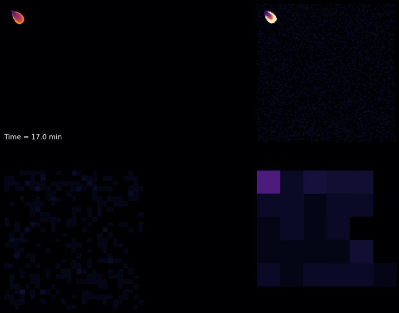
In this case the microwave land monitoring method would be useful for monitoring wildfires — everyone wants to know where they are in real time, but the gear in orbit right now simply can’t provide that information. Muon provided a simulation of how its satellites (top right) would be able to visualize a spreading fire compared with what’s up there (bottom row), which you can see below:
Simulation of monitoring a wildfire. Clockwise from top left, simulated ground truth, Muon’s satellites, GOES, VIIRS. Image Credits: Muon Space
This is just one of the many remote sensing opportunities out there relating to climate change and environmental monitoring and modeling, markets Muon is hoping to target first.
Notably, the spectrum that its first satellites monitor can be adjusted via software, much the way radios can be tuned that way — it can’t suddenly become an infrared detector, though it can change its mission to support other bands of interest. But beyond the passive microwave radar, Muon is hoping to take advantage of other technologies that have been pioneered but not yet deployed widely.
“We also have longer-term interest in other parts of the spectrum,” said Dyer. “Multispectral, hyperspectral, infrared … and there are optical architectures that allow a similar approach to collecting very broad bandwidths and then selecting what you need.”
Their plans include using instruments developed by agencies like NASA that have no active mission.
“It’s interesting,” put in McCleese, “NASA is putting a lot of effort into coming up with the means and technology of doing smallsats, but they’re largely in the field of demonstrations. There is an enormously rich area of demonstrated instruments by NASA, JAXA, etc. that are not being picked up for continuing observation. The demonstration was the focus, then the project comes to an end.”
A bunch of cutting-edge Earth observation tech sitting on a shelf just waiting for a tech transfer application is certainly a good place to start. Dyer said they will combine this with the company’s own accumulated expertise in the area and advances to “start from first principles in the ecosystem.”
“We want to provide a turnkey solution to formulate a set of sensors to address their problem, and go with them to full deployment of operations and data to meet their business needs. In many ways we think of the question of deploying sensors in space inside out,” he said, designing the satellite and data handling around the use case rather than vice versa.
The $25 million A round was led by Radical Ventures, with participation from Costanoa Ventures, Congruent Ventures, Space Capital and Ubiquity Ventures. “It definitely gets us to space, easily through the first three spacecraft, and it gets us to an MVP level on the support structure for those missions,” said Dyer.
Expect Muon’s first spacecraft to go up starting in November of next year on a SpaceX Falcon 9 ride-share mission if all continues to go well for them.
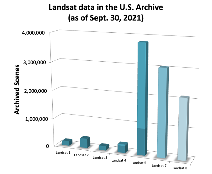
NASA’s Landsat satellites have consistently made history in Earth observation since the project’s first launch in 1972, with this year marking 50 years of innovation and science. Its influence may surprise you, as will its continued relevance in the face of a fast-growing commercial imaging satellite sector.
Landsat may be a familiar name to you but doesn’t ring any particular bells. It’s understandable — there are a ton of NASA satellites up there looking down on the planet. But the easiest way to say it is this: In 1972, Landsat basically invented modern Earth observation. Then, remember a while back when every Google Earth image said “USGS” on it? Yeah, that was Landsat too. The project has basically ushered satellite imaging from bleeding edge research tool to everyday technology.
Landsat 9 just launched last September, the latest in a long line of influential spacecraft.
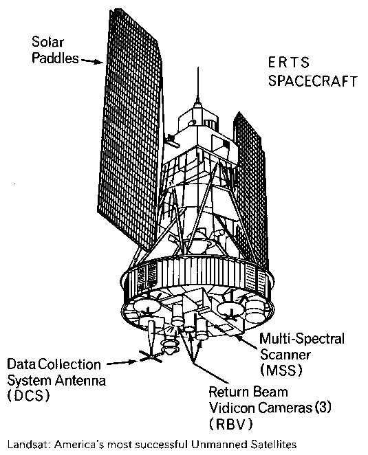
A schematic sketch of Landsat-1. Image Credits: NASA
I talked with Jim Irons, who has worked at NASA since 1978 and on Landsat since 1992. Irons told the story of Landsat from the beginning, both what he took part in himself and the lore he’s absorbed over the years. It’s fitting that for a project that would redefine Earth imaging, its very first satellite was both innovative and historically significant.
“Landsat 1 launched in 1972 — it carried two instruments, one was the Return Beam Vidicon, and it was kind of like a TV camera, it took analog data,” Irons said. “But Hughes [Aircraft Company] convinced NASA to put another instrument on the payload that was more experimental: the Multi-Spectrum Scanner. And it provided digital data.”
It hardly needs to be said that in 1972, digital anything was pretty innovative, let alone high-performance digital sensors in orbit. But the team clearly saw the writing on the wall, and good thing too.
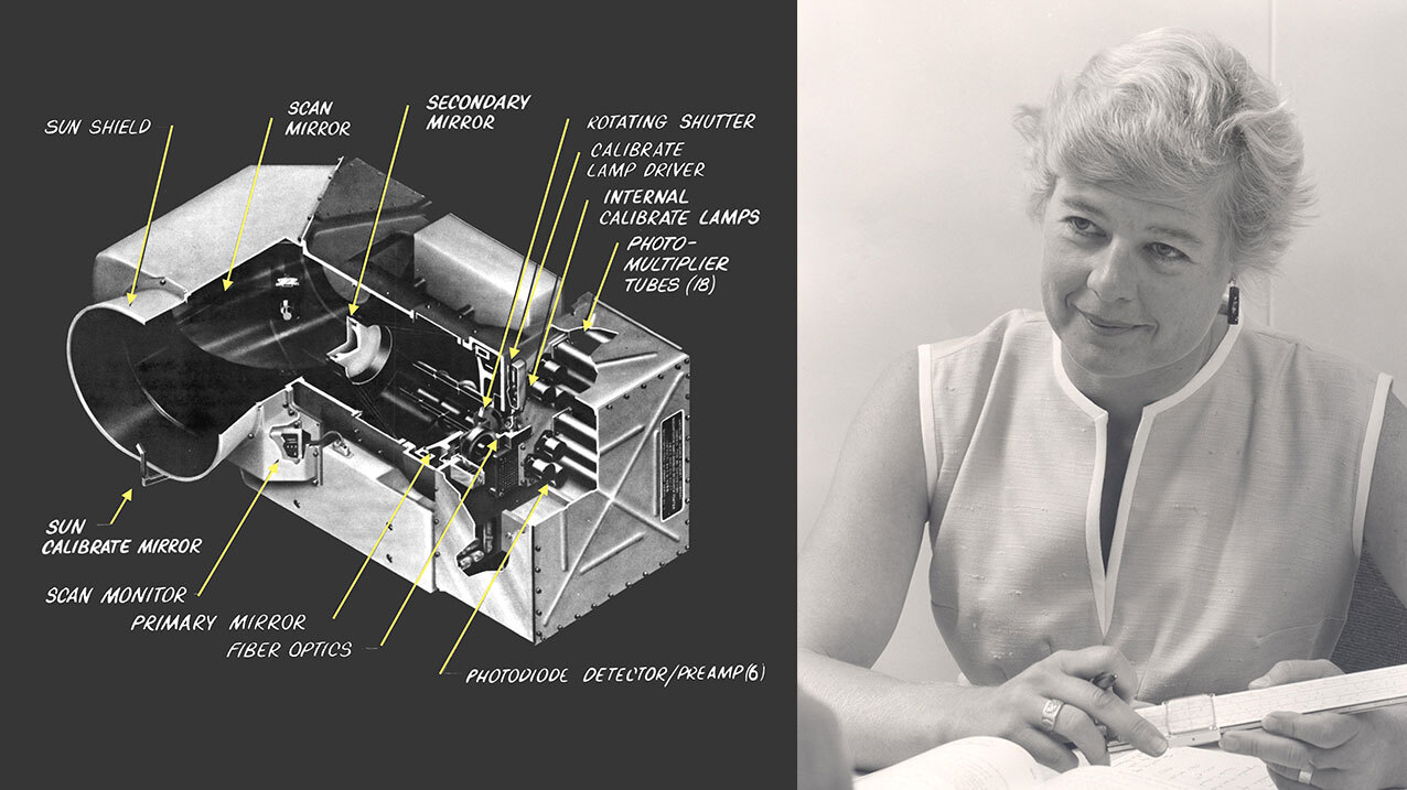
“After launch, the RBV had problems, and the data from the MSS became the preferred data. That was a big turning point,” recalled Irons. “It was an instrument that used an oscillating mirror that went back and forth to scan a path at 7-14 Hz, underneath the orbital path of the sensor, to create a digital image. And it’s mechanical! It was amazing.”
“The designer of this sensor, Virginia Norwood, she’s still with us, in her 90s. It was very unusual at the time to have a female engineer at all. She came to the launch of Landsat 9 last month, actually.”
Virginia Norwood (photo taken in 1972) with the MSS instrument she created. Image Credits: NASA
It’s a remarkable fact that the beginning of the orbital imaging revolution was the brainchild of one of the then-rare women in the space and tech industries, whose roles in many of the era’s important accomplishments have only recently begun to be given the attention they deserve. You can read more about Norwood’s role in the creation of the MSS, which is the precursor to many more such systems, at this NASA history article, or this more recent piece.
A successor to the MSS called the Thematic Mapper launched in 1982 with more spectral bands, but then in 1984 another big improvement struck a nerve at HQ:
“Landsat 5 in 1984 carried both a multispectral scanner and advancement on the thematic mapper idea that improved the spatial resolution of the data, from what had been 80 meters with the MSS to 30 meters, and spectral bands were added,” Irons said. “But there was all this data! Some people were afraid of that data, that analysts would be overwhelmed by it — but it didn’t turn out that way. Computer capacities kept up and soon the thematic mapper data was preferred.”
Image Credits: NASA
That would prove a rule as time went on and right up until the present: There really is no such thing as too much data. As long as you can collect it and store it, someone will find a use for it.
They might even pay you for it — but an attempt to privatize Landsat in the following years fell flat, or burned up on reentry in the case of Landsat 6, which never made it to orbit. Meanwhile, the private company created to operate and distribute the rest of the data jacked up the price until no one was willing to pay any more. “It was up to $4,400 per scene of thematic mapper data. People just stopped using it,” Irons said.
When NASA and the USGS, which handled the distribution of the imagery originally, returned to the reins, they had an international data recovery problem. Imagine having reams of data in a ground station in China or South America, long before ubiquitous broadband networks. How do you get it back to HQ in the States for central processing and analysis? I told Irons I was picturing big trucks full of hard drives, the internal combustion equivalent of Sneakernet.
“That’s exactly what happened!” he laughed. “They just drove up to the [USGS] facility with semi truck trailers full of magnetic tapes. It was difficult because they had all these different formats and instruments. So that created a little chaos. They bought pizza ovens to bake the water out of some of those tapes.” (I wanted to hear more about that part but our time was limited.)
Image Credits: NASA
But the repatriation of the data was only a precursor to an even larger shift.
“After Landsat 7 launched was perhaps the biggest change in the entire program,” Irons said. “USGS was still charging $600 for a mapper scene of data. And they made made what I consider an institutionally brave decision in 2008, to be consistent with NASA and provide Landsat data at no cost to anyone who wanted it. So it went from $400 to $600 to free.”
As you can imagine, this choice completely upended the model, and overnight, it changed everything.
“There was an explosion of use and redistribution of the data,” he continued. “Now, some places like Google Earth and Amazon Cloud Services, they’d gone in and downloaded the whole archive from USGS.”
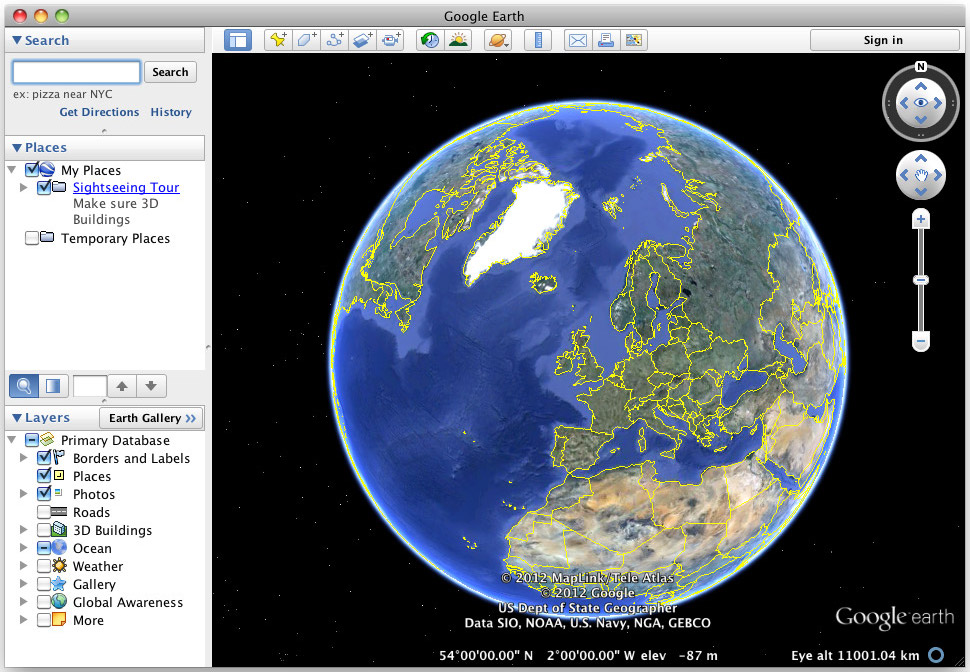
Remember the old Google Earth app? Image Credits: Google
That’s why for years, whenever you looked at an online map, it credited the USGS. Of course Google and Amazon didn’t own the imagery, or capture it themselves, though now all the majors are doing that at various scales. They simply downloaded a huge picture of the entire Earth and re-served it to their customers in a new form.
“It’s a struggle for us to brand the data and the program so taxpayers know they’re getting their money’s worth,” admitted Irons. It’s not like every time you opened Google Maps, it thanked you for making their business possible!
In the years since, Landsat 8 and 9 have launched with improved sensors and continued to collect invaluable data that is continuous with the previous decades — a free, long-term database of a large portion of the planet imaged every couple weeks or so depending on the era.
Image Credits: NASA
Of course nowadays constellations like Planet’s are imaging the whole globe on a daily basis. So why have Landsat at all?
“Those of us who work on Landsat are very impressed by what the commercial providers have achieved,” Irons said. “The message we want to get out is that Landsat is complementary to that data — they don’t replace Landsat data. One, it’s open and transparent access — that’s key, and it’s true of all the data collected by NASA satellites.
“Two, the USGS has maintained this 50-year archive of data. Is there a business case for companies to archive their data for decades, so we can observe the effects of climate change over the long term rather than just have short bursts of data? I don’t know that the business case is there.”
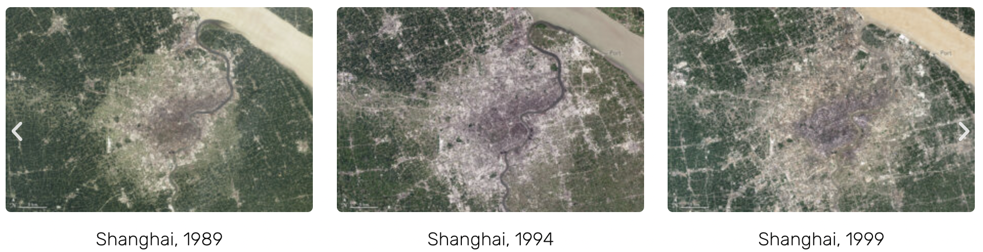
You can see an example of what decades of continuous data looks like here:
“And one of the things that enables our time series analyses is that NASA pays a great deal of attention to inter-sensor calibration,” Irons continued. “If you’re going from one Landsat image to another, you know it’s been calibrated — if you see a change over time, you can be clear that the thing is changing rather than the camera. [Commercial constellations] use Landsat data to do that; we serve as an industry standard to help them do their calibration.”
Here the conversation overlapped with what I talked about with Ginger Butcher, who’s done outreach for the project for years.
“We can compare a Landsat image today to a Landsat image from 1972,” she said. “That’s one of the tenets of the program: We have a dedicated calibration team keeping an eye on the instruments. Every full moon we turn the spacecraft around to use it as a kind of photographer’s grey card.”
With the increasing prominence of commercial providers in the U.S. space program, it was a real question over the last few years whether Landsat was worthwhile to continue funding, but arguments like those above won out.
“We used to have to work really hard to get that next mission, but now we’ve basically got the government saying this is a valuable resource worth continuing with,” Butcher said. “Now we’re looking to the future and what kind of capabilities we want to get out of the next Landsat. What kind of research are people doing? What additional wavelengths are needed for work on ice, or on forests, or particular areas in agriculture? For example, with thermal data we can look at crops and see if they’re being overwatered or underwatered — with water rights out west, that’s really important. As scientists take on new questions and new areas of study, they decide where Landsat goes next.”
More than ever, the project will work collaboratively with the commercial sector and with ESA satellites like Sentinel-2.
“We think it’s great,” said Irons. “The emergence of all these systems means the Landsat project has been incredibly successful; it basically created the market for them.”
Canadian startup Wyvern only just announced a $4.5 million seed round (which itself nearly doubled close to the wire thanks to new commitments) and entry into Y Combinator, and now it’s revealing that it has landed another $4 million in funding via Canada’s Sustainable Development Technology (SDTC) program.
The SDTC program offers startups at seed, growth and scale-up stages funding for projects that can potentially move the needle on clean tech, through partnerships with agencies and companies across public and private sectors. The funding they provide does not require that the startup hand over any equity, nor is it a loan with repayment expectations. Instead, it’s essentially a contract with measurable outcomes and deliverables set out by the SDTC and its partners, with access to the funding reliant on meeting those goals.
In Wyvern’s case, SDTC is working with a consortium including cardio digital farming (a BASF subsidiary), Olds College, SkyWatch, MetaSpectral and Wild + Pine. It outlines a three-year project that involves testing Wyvern’s hyperspectral, satellite-based imaging using Olds College’s 2,800 acre ‘smart farm’ facility.
Being flush with cash is incredibly important for Wyvern right now, since the company is working on actually getting its tech to space: The plan is to launch its first ‘DragonEye’ observation satellite this year.
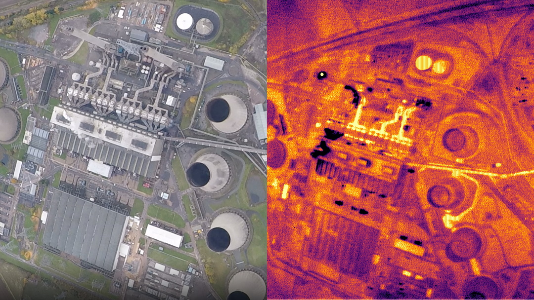
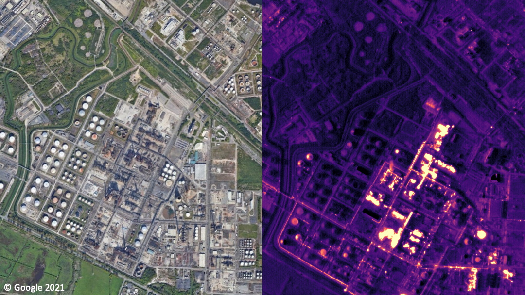
Earth imaging is an increasingly crowded space, but Satellite Vu is taking a different approach by focusing on infrared and heat emissions, which are crucial for industry and climate change monitoring. Fresh from TechCrunch’s Startup Battlefield, the company has raised a £3.6M ($5M) seed round and is on its way to launching its first satellite in 2022.
The nuts and bolts of Satellite Vu’s tech and master plan are described in our original profile of the company, but the gist is this: while companies like Planet have made near-real-time views of the Earth’s surface into a thriving business, other niches are relatively unexplored — like thermal imaging.
The heat coming off a building, geological feature, or even a crowd of people is an enormously interesting data point. It can tell you whether an office building or warehouse is in use or empty, and whether it’s heated or cooled, and how efficient that process is. It can find warmer or cooler areas that suggest underground water, power lines, or other heat-affecting objects. It could even make a fair guess at how many people attended a concert, or perhaps an inauguration. And of course it works at night.
You could verify, for instance, which parts of a power plant are active, when.
Pollution and other emissions are also easily spotted and tracked, making infrared observation of the planet an important part of any plan to monitor industry in the context of climate change. That’s what attracted Satellite Vu’s first big piece of cash, a grant from the U.K. government for £1.4M, part of a £500M infrastructure fund.
CEO and founder Anthony Baker said that they began construction of their first satellite with that money, “so we knew we got our sums right,” he said, then began the process of closing additional capital.
Seraphim Capital, a space-focused VC firm whose most relevant venture is probably synthetic aperture satellite startup Iceye, matched the grant funds, and with subsequent grant the total money raised is in excess of the $5M target (the extra is set aside in a convertible note).
“What attracted us to Satellite Vu is several things. We published some research about this last year: there are more than 180 companies with plans to launch smallsat constellations,” said Seraphim managing partner James Bruegger. But very few, they noted, were looking at the infrared or thermal space. “That intrigued us, because we always thought infrared had a lot of potential. And we already knew Anthony and Satellite Vu from having put them through our space accelerator in 2019.”
They’re going to need every penny. Though the satellites themselves are looking to be remarkably cheap, as satellites go — $14-15M all told — and only seven will be needed to provide global coverage, that still adds up to over $100M over the next couple years.
Image Credits: Satellite Vu
Seraphim isn’t daunted, however: “As a specialist space investor, we understand the value of patience,” said Bruegger. Satellite Vu, he added, is a “poster child” for their approach, which is to shuttle early stage companies through their accelerator and then support them to an exit.
It helps that Baker has lined up about as much potential income from interested customers as they’ll need to finance the whole thing, soup to nuts. “Commercial traction has improved since we last spoke,” said Baker, which was just before he presented at TechCrunch’s Disrupt 2020 Startup Battlefield:
The company now has 26 letters of intent and other leads that amount to, in his estimation, about a hundred million dollars worth of business — if he can provide the services they’re asking for, of course. To that end the company has been flying its future orbital cameras on ordinary planes and modifying the output to resemble what they expect from the satellite network.
Companies interested in the latter can buy into the former for now, and the transition to the “real” product should be relatively painless. It also helps create a pipeline on Satellite Vu’s side, so there’s no need for a test satellite and service.
Another example of the simulated satellite imagery – same camera as will be in orbit, but degraded to resemble shots from that far up.
“We call it pseudo-satellite data — it’s almost a minimum viable product.We work with the companies about the formats and stuff they need,” Baker said. “The next stage is, we’re planning on taking a whole city, like Glasgow, and mapping the whole city in thermal. We think there will be many parties interested in that.”
With investment, tentative income, and potential customers lining up, Satellite Vu seems poised to make a splash, though its operations and launches are small compared with those of Planet, Starlink, and very soon Amazon’s Kuiper. After the first launch, tentatively scheduled for 2022, Baker said the company would only need two more to put the remaining six satellites in orbit, three at a time on a rideshare launch vehicle.
Before that, though, we can expect further fundraising, perhaps as soon as a few months from now — after all, however thrifty the company is, tens of millions in cash will still be needed to get off the ground.
NASA is working with two other of its largest global space agency partners, the European Space Agency (ESA) and the Japan Aerospace Exploration Agency (JAXA) on a combined effort to collect satellite-based Earth observation data and provide it via a dashboard in order to help monitor the impacts of COVID-19. The dashboard combines data collected by Earth observation satellites operated by each of the agencies, which monitor photographic, air quality, temperature, climate and other indicators.
The COVID-19 Earth Observation Data provides views into changes globally in water quality, climate change, economic activity and also agriculture. It’s intended to provide policymakers, health authorities, city planners and others with key information that they can use to study both short- and long-term impacts of the ongoing global COVID-19 crisis, which is definitely changing the way that cities and the people within them work and live.
The agencies involved in the project formed a project for the purposes of building this in April, so it came together rather quickly for a cross-agency, international collaboration. Data so far indicates significant changes, including positive environmental ones around air and water quality due to decreased activity – but also significant slowdowns in key economic activity including shipping activity in ports, the number of cars in shopping mall parking lots, and more.
While the project is specifically intended to provide data around COVID-19 and its impacts, and the current plan only includes the pandemic within its scope, on a call discussing the initiative, ESA Director of Earth Observation Programmes Josef Aschbacher said that the agencies are already considering whether to extend he dashboard beyond the scope of COVID-19 since it could be useful in addressing any number of global-scale problems that we collectively face.